Snow chances all week with seasonably chilly temperatures
After a brief thaw on Sunday that included freezing rain and rain, mid-winter weather conditions have returned to Blue Mountain this week and will remain in place well into the New Year. Conditions on the slopes will continue to improve each day as groomers work the fresh natural snow in with the harder machine-made base underneath. Snow making operations are also back in full swing with the return of colder temperatures.
Location, Location, Location
This is the time of year where location means everything. Georgian Bay remains about 90% free of ice which brings huge snow potential in the days ahead. Brisk northwest winds will continue through New Year’s Day which will pile up the snow downstream. Computer models are hinting at an additional 15 centimetres by NYE and up to 30 centimetres by the weekend. These narrow streamers are notoriously hard to predict so check back daily to see how much falls at the hill. Regardless, the snow that arrives this week will be light and fluffy. You know the stuff that you can just float down the hill on!!!
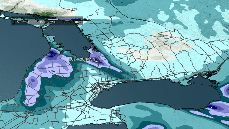
Snow Totals Through Thursday
Day to Day
Tuesday through Thursday: Periods of snow with brisk northwest winds. Bundle up out there and you’ll be rewarded with some great skiing and riding. Daytime temperatures in the -8C to -10C range, dropping to -12C for night skiing.
Friday to Sunday: More snow showers Friday with some weekend sunshine. Milder (-5C to -7C) with less wind. This will likely be some of the best skiing and riding of the entire holiday season!
Senior Meteorologist,Anthony Farnell